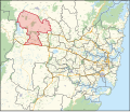
| Londonderry New South Wales—Legislative Assembly | |||||||||||||||
|---|---|---|---|---|---|---|---|---|---|---|---|---|---|---|---|
Interactive map of district boundaries from the 2023 state election | |||||||||||||||
| State | New South Wales | ||||||||||||||
| Dates current | 1988–present | ||||||||||||||
| MP | Prue Car | ||||||||||||||
| Party | Labor | ||||||||||||||
| Namesake | Londonderry | ||||||||||||||
| Electors | 63,842 (2019) | ||||||||||||||
| Area | 184.74 km2 (71.3 sq mi) | ||||||||||||||
| Demographic | Outer-metropolitan | ||||||||||||||
| Coordinates | 33°42′7″S 150°46′48″E / 33.70194°S 150.78000°E | ||||||||||||||
| |||||||||||||||
Londonderry is an electoral district of New South Wales. It was created in 1988.
Londonderry is in Greater Western Sydney.


